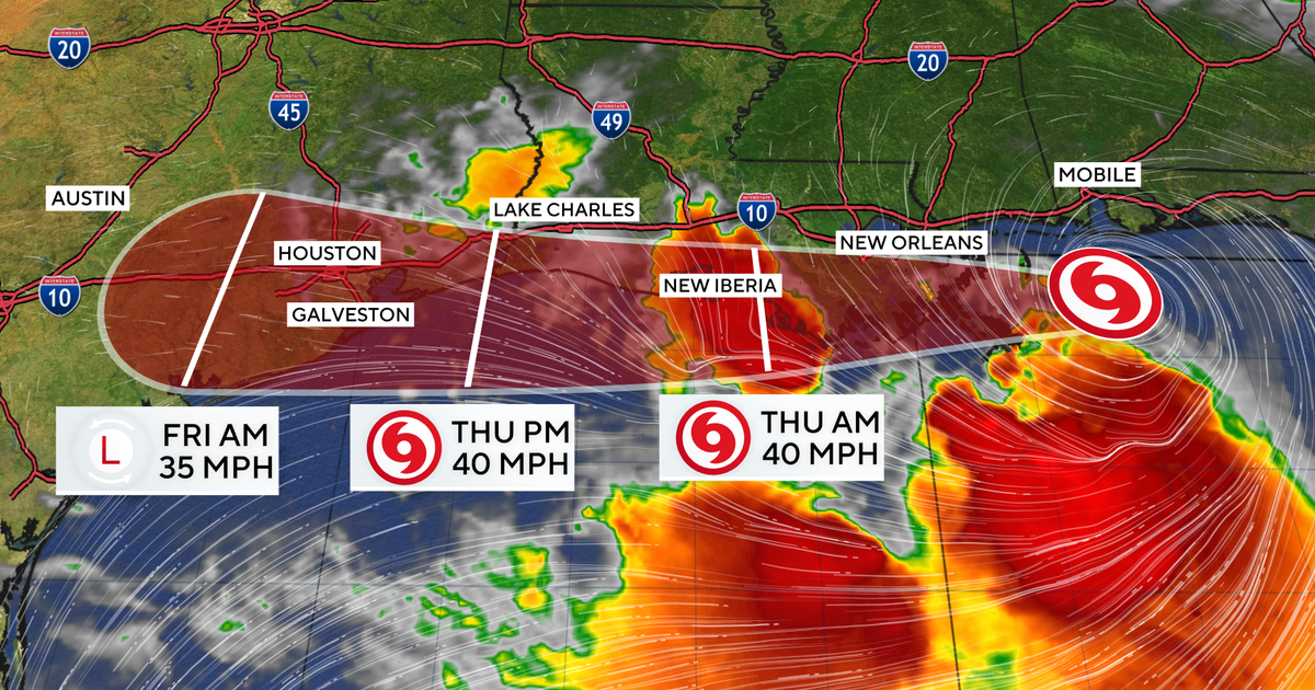
Tropical Storm Bertha is bringing rain to large swaths of the northern Gulf Coast on Wednesday, as its projected path sparked watches and warnings. Bertha is in the Gulf of Mexico and approaching the southeastern Louisiana coast, crawling westward "with little acceleration," the National Hurricane Center said . It is expected to impact coastal areas from the Florida Panhandle to Texas, including some major cities.
Forecasters said the storm would move over the New Orleans area Wednesday night before continuing on toward Houston and then dissipating by the end of the week. Beaches were closed from Florida to Mississippi on Wednesday, as Bertha dispensed tropical-storm-force winds more than 100 miles outward from its center. Bertha, the second named storm of the Atlantic hurricane season , is forecast to stick close to the coast.
The Miami-based hurricane center said it expects the system to continue gradually weakening as it moves near or along the northern Gulf Coast over the next couple of days. As of the center's latest update Wednesday, the storm had maximum sustained winds of 45 mph, which have been decreasing gradually since Tuesday night. The storm was expected to make landfall later on Wednesday, although Robbie Berg, a warning coordination meteorologist at the hurricane center, told The Associated Press that it wasn't much of a threat.
"Landfall really doesn't have a whole lot of meaning in this particular case," Berg said. Candice Henderson, who manages a beachside restaurant called the Crab Trap in Pensacola, told the AP that, for local residents, "this is just another storm." But officials in Florida, Louisiana and Mississippi still opened sites where people could acquire sandbags, while some beaches were closed to swimmers. Tropical storm watches were expanded Wednesday to include coastal parts of southwestern Louisiana and northeastern Texas, as the storm traveled in their direction.
Tropical storm warnings were in effect from the Alabama-Florida state line to Morgan City, Louisiana, as well as for a stretch of the coast between New Orleans and Lake Pontchartrain. A tropical storm watch was also posted for the area west of Morgan City to Sargent, Texas, and for Lake Maurepas in Louisiana. "Tropical storm conditions will continue spreading across portions of the northern Gulf Coast within the warning area today," the hurricane center said early Wednesday.
"Tropical storm conditions are possible within the watch area in Louisiana by tonight and along the upper Texas coast by Thursday or Thursday night." The storm "is expected to produce total rainfall amounts of 1 to 4 inches with isolated higher totals to 6 inches through Thursday along the central to the western Gulf Coast from western Florida to southern Texas," it said. "This rainfall may produce isolated flash flooding, especially in urban areas." The system could also produce storm surge, raising waters up to 3 feet in some locations along the coast. Bertha comes weeks after the 2026 hurricane season's first named storm, Tropical Storm Arthur , which made landfall in June along the Gulf Coast of Texas.
The Associated Press and Ashton Altieri contributed to this report. Why is Tropical Storm Bertha named Bertha? Here's how hurricanes get their names First Alert Weather Days active in North Texas for extreme heat Storms bring multiple tornado warnings to western Pennsylvania Tornado watch expires after severe storms hit Philadelphia region Everything You’ve Read About Chinese Cars Is Wrong James Fishback: The Right-Wing Troll Who Would Be Governor